Highly Interactive Innovation District in Ho Chi Minh City
Location: Ho Chi Minh City, Vietnam
Client: City of Ho Chi Minh City
Status: Completed, Sasaki and EnCity
Awards:
Fast Company World Changing Ideas Awards, Finalist—Asia Pacific Category
Fast Company World Changing Ideas Awards, Honorable Mention—Spaces, Places, and Cities Category
Published Material:
Ho Chi Minh City People’s Committee. Summary of Key Concepts and Ideas: Conceptual Planning and Development Strategy for a Highly Interactive Innovative District in the East of Ho Chi Minh City from Participating Proposals in the International Competition “Conceptual Planning and Development Strategy for a Highly Interactive and Innovative District in the East of Ho Chi Minh City (Composed of District 2, District 9 and Thu Duc District).” Workshop material, November 2019.
Holmes, Damian. 2019. “Sasaki Wins Ho Chi Minh City Innovation District Competition.” World Landscape Architecture. December 9, 2019.
Parrish, Cayleigh. 2020. “See the 26 World Changing Ideas Awards Winners That Are Building a Better World.” Fast Company. April 28, 2020.
Pham, Xuan. 2021. “Thu Duc City - The Quintessential City.” JLL. March 30, 2021.
Di Thiên. 2025. “Thu Duc City projected to become international financial hub by 2040.” Vietnam Economic Times. January 29, 2025.
In Eastern Ho Chi Minh City, the “Interactive Innovation District” reimagines Districts 2, 9, and Thu Duc (now Thu Duc City) as a connected landscape of laboratories, classrooms, factories, and neighborhoods rather than separate zones on a map. Anchored by universities, research institutes, and emerging tech hubs, the district is designed to help steer the city toward a knowledge-based economy in the era of the Fourth Industrial Revolution. High-density clusters of research, development, and production are intentionally woven together with housing, public space, and social infrastructure so that collaboration is not an occasional event but an everyday condition. The aim is to generate high-value jobs, deepen economic resilience, and pair state-of-the-art infrastructure with supportive policy frameworks that allow new industries to take root while enhancing quality of life.
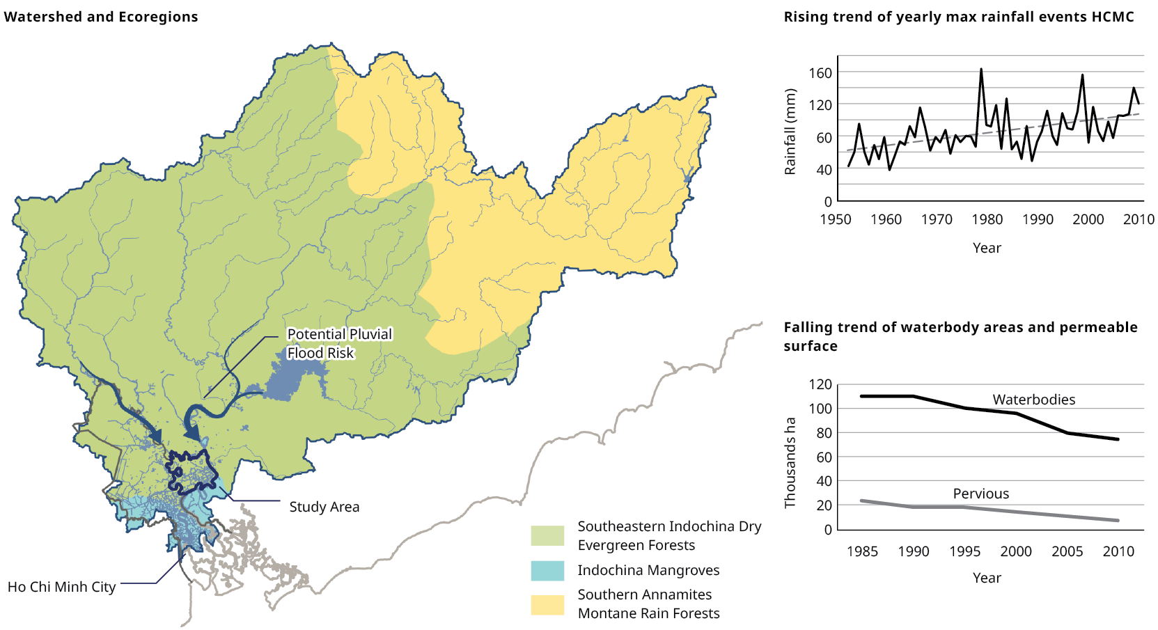
The site’s rivers and wetlands make it an ecological as well as economic frontier. This landscape is both an asset and a vulnerability, exposed to recurrent flooding and the long arc of climate change. Resilient design is therefore central to the project: sustainable water management, natural flood barriers, and green infrastructure are treated not as add-ons but as structuring elements of the district. Transit-oriented development, shaded public realms, and accessible green corridors are planned to make the district attractive to researchers, professionals, and long-term residents alike, building an innovation ecosystem that is as attentive to environmental limits as it is to technological ambition.

Regional Development Framework

Project Concept and Context

Illustrative Representation of the Urban Design

Flood Risk and Urban Expansion Context
Hydrological Context

Key Challenges
Climate Change and Resilience
Located outside Ho Chi Minh City’s flood infrastructure, the HIID boundary requires strategies to manage internal flooding as open spaces are developed. Key climate challenges—flash flooding, tidal flooding, urban heat, land subsidence, and saltwater intrusion—affect water quality, biodiversity, and resilience. To address these, robust standards, monitoring, and protection of green spaces are needed. Converting agricultural land to real estate reduces hydrological capacity and raises flood risk, highlighting the need to balance development with ecological resilience.

Tidal Flood Risk
Strategies for a Landscape Approach
To preserve HIID’s hydrological function, prevent pluvial flooding, and meet HCMC’s open space standards, planning must balance new development with ecological protection. Guidelines on open space typologies can support a diverse park system, while strategies should protect key ecological areas, improve blue-green networks, and integrate stormwater management from source to larger water bodies, including internal drainage and natural features. These strategies, grounded in ecosystem sensitivity and flood risk mapping, may be refined with further analysis to ensure resilient, sustainable development.


Rapid Landscape Classification